Thank you so much! You are a lovely person :)
On Thu, Aug 19, 2010 at 12:07 AM, Timothy Joyce <thjoyce@peoplepc.com> wrote:
God's Bath
Daniel:
Yeah, I noticed the posting from that teacher and her students a while back. I also figured out that Pancho listed the wrong service road by accident. Right road, wrong service road number.
You were way off in no where land about 50 miles south of your destination (God's Bath). That makes you number 173!
The Clavey only has limited means for access (2-3 roads cross the river). I've been up and down all of them. Tub City a great swimming hole is off of the middle road. Only good for access
at the end of this month.
From Tuolumne City you need to find Cotton Wood Road (Buchanan road). This is a paved road that goes all the way to Cherry Lake. It is an easy and pleasant drive all the way out.
It is a little steep at the start, but the road is in good shape.
Just follow it out 19 miles to the bridge over the Clavey River. The parking spot is just after the bridge on the right. There is a sticker on the bridge guard rail that says "no bungee jumping".
The trail is on the right side of the bridge if you are looking up river (left side in the photo below just after the guard rail). I've tried them all, but this is the only real way down (see photo below). There is a small rope to help you with the 3rd class scramble
down to the river (see photo below). This is the hardest part of the trail. The trail is not easy to find. Just stay to the right all the way up to the swimming hole. It is about 3/4 of a mile to a mile of boulder
hopping to get to the swimming hole.
About half way on the hike, you may have to either make a wet entry or use a small rope to climb on a small ledge (see photo below).
Please sign up on my blog as a follower. This will help get some discounts. Members may get access to some "secret" swimming holes I plan on posting later in the year.
Also, I am in the process of writing my own book that will tie in with the website.
Note if you plan any other trips, feel free to email me. A number of the directions in the book and distances are way off (North Canyon, Cleo's Bath, and many others).
Bring extra water, the canyon gets hot and the elevation is higher than you might think.
Good Luck!
-----------------------------------------------------------
Type of GPS to Use
Tim
I use a Garmin (car version). I don't recommend the hiking style GPS units. They are expensive and junk. I tried them and they are no more accurate and
provide no added value. Maybe in the future when they can track trails correctly.
I don't see a problem with the iphone GPS. Most places though you will lose reception via telephone. Verizon has by far the best coverage. I've been
in some really remote places and was the only one with reception using Verizon.
I am not sure about the range on the telephone GPS units. From what I have seen they appear to work the same with the same satellite reception.
I'm going to research the issue. I will get back to you in a few weeks with a better answer. I will also compare Garmin,
Blackberry and the iphone. I think batter life is also an important issue.
If you buy a Garmin, I would do it at Fry's. I would get the 2 year warranty. Then if the thing craps out on you, just bring it in and get a new
one at no charge. I usually use a GPS 8 hours a day for 365 days. They usually go about 1.5 years and then I get another new model under
then plan. This saves a lot of problems and keeps my unit updated for usually only $70.00.
Tim
On 8/16/2010 2:01 PM, Matt Harrington wrote:
Dear Timothy,
I stumbled across your blog recently. I too have been exploring the swimming holes of California for quite a while. I'm curious about your choice of GPS. What do you think about just using an iPhone?
Matt
For liability purposes I don't recommend swimming holes. You swim at your own risk. However, here are a few suggestions.-------------------------------------------------------------
The best options would be University Falls, and Mammoth Hole. They are the only ones that meet your distance requirements.
Anything on the Yuba River should also work. Mountain Dog is under 1 mile and is at Edward's Crossing.
University Falls, Mountain Dog and Mammoth hole are good for kids. Oregon Creek is the nicest hole going in that direction, but there is no hike
to the hole.
They are all on the way to Tahoe. If you want something close with a great hike, views, and nature, I would go to the Palomarin
Trail and Bass Lake. However, this is not on the way to Tahoe. However, it probably is only about 40 minutes or less a drive
for you. The kids love the rope swing.
Note: University Falls has some neat rock water slides. The last slide should be avoided. A few people have been killed going
over the edge.
http://besthikeca.blogspot.com
Also, please sign on my site as a follower. We are trying to grow the membership to get discounts. Later in the year I may be
posting some "secret" swimming holes for only members.
Tim
On 8/18/2010 10:47 PM, Liah Hansen wrote:
Howdy!
I found your swimming hole blog and the email on it. You've done quite the photographic documentary! Thanks for the community service :)
I'm planning a trip to a swimming hole this weekend and am feeling a bit overwhelmed by all the options. I'm looking for a naturey hole with a 1-2 mile hike each way. We are coming from San Francisco and are hoping to find a spot within 3-4 hours of driving and even better if it is on the way to Tahoe.
Any recommendations?
Thanks so much!
Liah :)
God's Bath
Daniel:
Yeah, I noticed the posting from that teacher and her students a while back. I also figured out that Pancho listed the wrong service road by accident. Right road, wrong service road number.
You were way off in no where land about 50 miles south of your destination (God's Bath). That makes you number 173!
The Clavey only has limited means for access (2-3 roads cross the river). I've been up and down all of them. Tub City a great swimming hole is off of the middle road. Only good for access
at the end of this month.
From Tuolumne City you need to find Cotton Wood Road (Buchanan road). This is a paved road that goes all the way to Cherry Lake. It is an easy and pleasant drive all the way out.
It is a little steep at the start, but the road is in good shape.
Just follow it out 19 miles to the bridge over the Clavey River. The parking spot is just after the bridge on the right. There is a sticker on the bridge guard rail that says "no bungee jumping".
The trail is on the right side of the bridge if you are looking up river (left side in the photo below just after the guard rail). I've tried them all, but this is the only real way down (see photo below). There is a small rope to help you with the 3rd class scramble
down to the river (see photo below). This is the hardest part of the trail. The trail is not easy to find. Just stay to the right all the way up to the swimming hole. It is about 3/4 of a mile to a mile of boulder
hopping to get to the swimming hole.
About half way on the hike, you may have to either make a wet entry or use a small rope to climb on a small ledge (see photo below).
Please sign up on my blog as a follower. This will help get some discounts. Members may get access to some "secret" swimming holes I plan on posting later in the year.
Also, I am in the process of writing my own book that will tie in with the website.
Note if you plan any other trips, feel free to email me. A number of the directions in the book and distances are way off (North Canyon, Cleo's Bath, and many others).
Bring extra water, the canyon gets hot and the elevation is higher than you might think.
Good Luck!
-----------------------------------------------------------
Type of GPS to Use
Tim
I use a Garmin (car version). I don't recommend the hiking style GPS units. They are expensive and junk. I tried them and they are no more accurate and
provide no added value. Maybe in the future when they can track trails correctly.
I don't see a problem with the iphone GPS. Most places though you will lose reception via telephone. Verizon has by far the best coverage. I've been
in some really remote places and was the only one with reception using Verizon.
I am not sure about the range on the telephone GPS units. From what I have seen they appear to work the same with the same satellite reception.
I'm going to research the issue. I will get back to you in a few weeks with a better answer. I will also compare Garmin,
Blackberry and the iphone. I think batter life is also an important issue.
If you buy a Garmin, I would do it at Fry's. I would get the 2 year warranty. Then if the thing craps out on you, just bring it in and get a new
one at no charge. I usually use a GPS 8 hours a day for 365 days. They usually go about 1.5 years and then I get another new model under
then plan. This saves a lot of problems and keeps my unit updated for usually only $70.00.
Tim
On 8/16/2010 2:01 PM, Matt Harrington wrote:
Dear Timothy,
I stumbled across your blog recently. I too have been exploring the swimming holes of California for quite a while. I'm curious about your choice of GPS. What do you think about just using an iPhone?
Matt
---------------------------------------------------------------
Consumnes & Bass Lake
Jena:
Nothing fits that description in Pancho's book.
I recommend Bass Lake. It is less than an hour away. The hike is a little longer than you suggest, but the rope swing is one of the best in CA!
Also, you get beautiful Eucalyptus trees and a great view of the ocean. See:
http://besthikeca.blogspot.com/
Bass Lake
From San Francisco, take RT 101 across the Golden Gate then RT 1 north. Just past Bolinas Lagoon, turn left at the exit to Bolinas (may be unsigned). Follow the road along the lagoon until it ends then take Olema-Bolinas Road to the stop sign at Mesa Road. Go right on Mesa Rd. and go about 4 miles where it turns to dirt and ends at a parking area. There is a sign at the trailhead by the lot which will direct to Palomarin Trail. The hike to the lake is about 2.3 to 2.6 miles one way. Although the ocean breeze makes this hike fairly cool in the summer you should still bring water.
Your hike will take you past a grove of eucalyptus trees. After you pass the eucalyptus trees you will pass by a cliff on your left that gives you a beautiful view of the Pacific ocean. You then will proceed up a hill for about 1 mile. You then come to a trail intersection that reads "Coast Trail" , Wildcat camp 3.3 miles or Palomarin trail 2.2 miles. Stay on the Palomarin trail. Follow this trail until you reach another trail marker that says "Bass Lake". You turn left at this sign and follow the trail down to the lake. You will know you are on the right trail since you will get a view of the lake on your left.
The actual trail to the waters edge is not easy to locate. It is about 0.06 miles down on the left just past the end of the lake. It is not easy to spot on your left since there is much poison ivy. You know you have missed it if the trail starts to slightly ascend and the canopy begins to thicken. If you take this trail it will take you to a clearing close to the lake where most people camp and sun bathe. The rope swing is another 0.2 miles past this small camp. In the attached photos you can see the tree with the rope swing (it is the large tree on the water at about 1 PM in both photos). On a hot day I have seen up to 30-40 people here. Most of the time you will have the place to yourself.
Consumnes River
The other option is to go to Consumnes River that is about 2.5 hours away. It is just south of Sommerville where the road crosses the Consumnes at the
Middle Fork. The parking is just before the bridge. There are two rope swings here. No real hike to the river. Just climb down a small hill.
This is mostly a family hole and a great place for young kids.
Tim
On 8/6/2010 10:31 AM, Jena Yankovich wrote:
Candy Rock
Note: Candy Rock is located in Murphy's and not Sonora.
From Sonora
Left on Golf Links Rd.
Right on Jamestown
Left on Shaw's Flat to cross over Highway 49
(continue on Shaw's Flat)
Left on Parrott's Ferry Road
Right on Highway 4
Continue to Hunter Dam Rd.
Right on Hunter Dam Rd. (becomes Candy Rock Road further down)
(3 miles on this road) Road is bumpy until parking area. The road is all dirt with lots of rocks, but
minimum pots holes. It gets steeper near the end and in some places you are driving along a one lane
dirt road on the side of a cliff. There is a large parking lot at the end of Candy Rock Road. The
trail to the swimming hole is to the rear left as you face the river from the parking lot.
About 0.5 miles to swimming hole from parking. The hike down to the river is pretty steep, so take is slow. Water shoes are recommended because the rocks are pretty slippery around the hole. This drive and hike down is not recommended unless you are in good shape. The Canyon gets pretty hot, so bring lots of extra water. Water temperature is moderate to cold. However, not bone chilling cold like many of the swimming holes in Yosemite.
If you have a GPS, just put in Hunter Dam Road. Confirm directions with another source. Let me know if you make it.
Tim
On 7/28/2010 3:25 PM, Sammy Love wrote:
Long Canyon
How to get there: From Sacramento, drive east on I-80 to the north end of Auburn and Elm Street exit. Take the Elm Street exit and turn left at the first stoplight onto Elm Street and drive 1/10th of a mile to High Street. Turn left on High Street, and continue through the signal where High Street merges with Highway 49. Continue on Highway 49 about 31/2 miles, turn right over the bridge, and drive about 21/2 miles into the town of Cool to Georgetown Road/Highway 193. Turn left on Georgetown Road/Highway 193 and drive about 14 miles into Georgetown to the four-way stop at Main Street.
Turn left on Main Street (which becomes Wentworth Springs Road ) and drive about 25 miles to 11 Pines Road (Forest Service Road 2). Turn left on 11 Pines Road (also signed for Hell Hole) and drive 23 miles (one mile past the Hell Hole Campground access road) to the parking area at the boat ramp.
Don't trust Pancho's Forest Service numbers.
On 7/25/2010 11:51 PM, Timothy Joyce wrote:
Here is an article with directions to the Reservoir.
http://articles.sfgate.com/2005-08-11/sports/17384281_1_trout-campgrounds-boat
Tim
On 7/25/2010 11:29 PM, Timothy Joyce wrote:
What is the name of it? Long Canyon is the one I gave you below.
The one Pancho is talking about is close to the Reservoir. If you continue up the same road you get to Hell Hole Reservoir.
I remember it to be fairly close.
All the swimming holes Pancho lists are fairly easy to get to. If you find yourself on a dirt road in a deep canyon you are going
to some other swimming hole.
On 7/25/2010 11:06 PM, Peter Hobart wrote:
Thanks much, I'll check it out next time I'm up there. But I think the swimming hole in Pancho's book is down the canyon almost at the junction of the Rubicon with Long Canyon Creek- way down, maybe a different hole?.
On Jul 25, 2010, at 10:27 PM, Timothy Joyce wrote:
On 7/25/2010 8:14 PM, Peter Hobart wrote:
If you get lost just go the the campground (Big Meadow Campground). This is basically a campground
swimming hole. As I recall you cross a concrete bridge that water runs across. At the campground just go toward the river and follow it down.
It is not far.
The road is in good condition and can be easily driven using a Toyota Corolla.
If you still can't find it call me 650-814-4251.
----------------------------------------------------------------
Oregon Creek
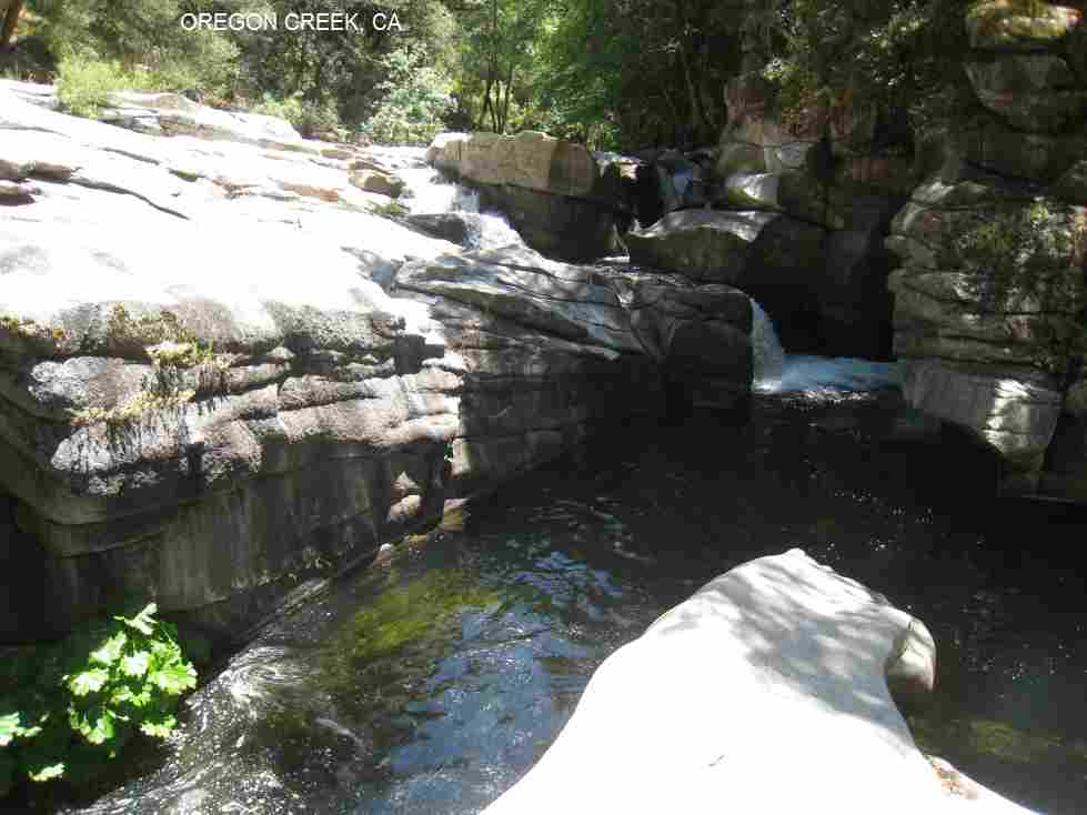
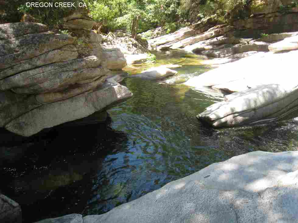
OREGON CREEK [OREG]: Beautiful hole with large flat rocks all around. Clothing optional. PHOTO , PHOTO, PHOTO . This is not a deep hole - maybe about 6-8 feet max. DO NOT DIVE HERE- there have been a number of injuries. There is also a few little tubs that have circulating water that acts like a hot tub. One falls steps down and the other braids together. You can actually go under the falls. There is an air space and plenty of room for about 3 people. Also at the top of the step down falls is a pot hole you can submerge into and go through a secret passage to the middle rock where you can come up. It is very neat.
To get here, set your odometer at the Middle Yuba Bridge and go a little under 1.0 mile north on RT 49 from the bridge over the Middle Yuba and park at a small turn off on the right side of the road (look closely, this turn off is not easy to find. Note that right before the turn off there is a rusted guard rail with a white road marker that says YUB 49. That is the first marker you will see while driving. Next to this marker and closer to the parking place is a second white marker that has the number 101 on it. If you still can't find it and are in doubt, the road is marked here with the number 213') . There is a big dirt hump at the parking area you go over to get to the trail. Walk a short way (.25 miles) or less down a well-maintained trail to Oregon Creek and the swimming hole. LAT, LON : lat=39.404972, lon=-121.0754(source: measured by another) (accuracy: exact) LINK TO GOOGLE MAP. Very confident. Verified by another. Updated 5/10.
On 7/23/2010 2:43 PM, Nathan Lehman wrote:
Middle Rock Creek
Jo:
Thanks a lot for your email. I don't get many emails like that!
Rock Creek isn't posted as I recall. It is in Plumas National Forest. However, Pancho Doll has some directions in his book.
I was at Rock Creek a few weeks ago. It is a little tricky to find. The road you are looking for is a dirt road just after a bridge that crosses the feather river. There is a small tributary that runs down into the feather river right where the bridge crosses the river. It is a little beyond the Grizzly Creek tributary and tunnels and will be on your left if you are driving from Chico.
The road is unmarked and goes up fairly steeply to an unlevel dirty parking lot. As I recall
it is fairly bumpy and there are 3-4 or more steep switch backs. The road goes up very steeply after the parking lot and is generally not possible without a four wheel truck. Most people park at this parking area and then walk up the road.
The trail will be on the left after you proceed up the next grade. It travels along the right side of the
river for a short distance and then you have an option to climb on a cliff to the right or cross the river.
Most people cross the river. The swimming hole is about 100 yards further up.
Note that there is also a good swimming hole further down and off Rt. 70 called Indian Falls.
I will be posting the directions and photos for that fairly soon. The water quality isn't so bad,
but not the level of the Feather River. There is a great jumping rock, awesome beach, and
plenty of rocks to lay out on. There are more crowds here though.
On 8/3/2010 9:57 AM, Jo Thornton wrote:
> Hi Timothy,
> Thanks for posting all this info on your blog. I ve had a
blast hiking with my kids to these swimming holes. My motive, of
course, was to get their bums off the couch and away from video games
while getting to spend some quality time with them. Their motive,
of course, was FUN. That we've had.
> We are preparing to go to Rock Creek in the Chico area. I
printed off the google map directions but after driving 30.9 miles on
CA-70 it tells me to turn left on "unknown road". Do you have any
idea what the name of this road is? I thought perhaps somebody
had written in to let ya' know.Again, thanks for posting this blog. It has enabled our
family to have loads of fun this summer!
> Jo Thornton
Consumnes & Bass Lake
Jena:
Nothing fits that description in Pancho's book.
I recommend Bass Lake. It is less than an hour away. The hike is a little longer than you suggest, but the rope swing is one of the best in CA!
Also, you get beautiful Eucalyptus trees and a great view of the ocean. See:
http://besthikeca.blogspot.com/
Bass Lake
From San Francisco, take RT 101 across the Golden Gate then RT 1 north. Just past Bolinas Lagoon, turn left at the exit to Bolinas (may be unsigned). Follow the road along the lagoon until it ends then take Olema-Bolinas Road to the stop sign at Mesa Road. Go right on Mesa Rd. and go about 4 miles where it turns to dirt and ends at a parking area. There is a sign at the trailhead by the lot which will direct to Palomarin Trail. The hike to the lake is about 2.3 to 2.6 miles one way. Although the ocean breeze makes this hike fairly cool in the summer you should still bring water.
Your hike will take you past a grove of eucalyptus trees. After you pass the eucalyptus trees you will pass by a cliff on your left that gives you a beautiful view of the Pacific ocean. You then will proceed up a hill for about 1 mile. You then come to a trail intersection that reads "Coast Trail" , Wildcat camp 3.3 miles or Palomarin trail 2.2 miles. Stay on the Palomarin trail. Follow this trail until you reach another trail marker that says "Bass Lake". You turn left at this sign and follow the trail down to the lake. You will know you are on the right trail since you will get a view of the lake on your left.
The actual trail to the waters edge is not easy to locate. It is about 0.06 miles down on the left just past the end of the lake. It is not easy to spot on your left since there is much poison ivy. You know you have missed it if the trail starts to slightly ascend and the canopy begins to thicken. If you take this trail it will take you to a clearing close to the lake where most people camp and sun bathe. The rope swing is another 0.2 miles past this small camp. In the attached photos you can see the tree with the rope swing (it is the large tree on the water at about 1 PM in both photos). On a hot day I have seen up to 30-40 people here. Most of the time you will have the place to yourself.
Consumnes River
The other option is to go to Consumnes River that is about 2.5 hours away. It is just south of Sommerville where the road crosses the Consumnes at the
Middle Fork. The parking is just before the bridge. There are two rope swings here. No real hike to the river. Just climb down a small hill.
This is mostly a family hole and a great place for young kids.
Tim
On 8/6/2010 10:31 AM, Jena Yankovich wrote:
Hey Tim.----------------------------------------------------------
My name is Jena and I love, love, love swimming holes. I grew up in Santa Cruz so no idea where this fascination has come from.
I have Pancho’s book but want your opinion on a swimming hole to take my 9 and 11 year old kids to next weekend. I have a hard time figuring which one to go to.
I am hoping you can give me a suggestion:
I don’t want to drive too far, max three hours and I live in San Jose.
Would love one with a rope swing
Not too bad of a hike, under 1/2 hour
Not too crowded.
Thank you and looking forward to hearing from you.
Jena
Candy Rock
Note: Candy Rock is located in Murphy's and not Sonora.
From Sonora
Left on Golf Links Rd.
Right on Jamestown
Left on Shaw's Flat to cross over Highway 49
(continue on Shaw's Flat)
Left on Parrott's Ferry Road
Right on Highway 4
Continue to Hunter Dam Rd.
Right on Hunter Dam Rd. (becomes Candy Rock Road further down)
(3 miles on this road) Road is bumpy until parking area. The road is all dirt with lots of rocks, but
minimum pots holes. It gets steeper near the end and in some places you are driving along a one lane
dirt road on the side of a cliff. There is a large parking lot at the end of Candy Rock Road. The
trail to the swimming hole is to the rear left as you face the river from the parking lot.
About 0.5 miles to swimming hole from parking. The hike down to the river is pretty steep, so take is slow. Water shoes are recommended because the rocks are pretty slippery around the hole. This drive and hike down is not recommended unless you are in good shape. The Canyon gets pretty hot, so bring lots of extra water. Water temperature is moderate to cold. However, not bone chilling cold like many of the swimming holes in Yosemite.
If you have a GPS, just put in Hunter Dam Road. Confirm directions with another source. Let me know if you make it.
Tim
On 7/28/2010 3:25 PM, Sammy Love wrote:
-------------------------------------------------------------Yes, that is my real name......Samuel Charles Valentine Love Junior, or Sammy Love for short. That would be awesome if you could send directions! I'm trying to go next week or the week after that, in the middle of the week that is. Sammy On Jul 28, 2010, at 2:26 PM, Timothy Joyce wrote:We have not posted the directions. Let me know if you want me to send them to you. By the way, is that your real name? Tim On 7/28/2010 1:52 PM, Sammy Love wrote:Hi, my name is Sammy Love. I was looking for a place to go on a road trip and found your blog to be a great inspiration! I am trying to find "Candy Rock", the last photo on your blog, and can't seem to find it in google. Could you let me know where it is? Thanks, Sammy Love
Long Canyon
How to get there: From Sacramento, drive east on I-80 to the north end of Auburn and Elm Street exit. Take the Elm Street exit and turn left at the first stoplight onto Elm Street and drive 1/10th of a mile to High Street. Turn left on High Street, and continue through the signal where High Street merges with Highway 49. Continue on Highway 49 about 31/2 miles, turn right over the bridge, and drive about 21/2 miles into the town of Cool to Georgetown Road/Highway 193. Turn left on Georgetown Road/Highway 193 and drive about 14 miles into Georgetown to the four-way stop at Main Street.
Turn left on Main Street (which becomes Wentworth Springs Road ) and drive about 25 miles to 11 Pines Road (Forest Service Road 2). Turn left on 11 Pines Road (also signed for Hell Hole) and drive 23 miles (one mile past the Hell Hole Campground access road) to the parking area at the boat ramp.
Don't trust Pancho's Forest Service numbers.
On 7/25/2010 11:51 PM, Timothy Joyce wrote:
Here is an article with directions to the Reservoir.
http://articles.sfgate.com/2005-08-11/sports/17384281_1_trout-campgrounds-boat
Tim
On 7/25/2010 11:29 PM, Timothy Joyce wrote:
What is the name of it? Long Canyon is the one I gave you below.
The one Pancho is talking about is close to the Reservoir. If you continue up the same road you get to Hell Hole Reservoir.
I remember it to be fairly close.
All the swimming holes Pancho lists are fairly easy to get to. If you find yourself on a dirt road in a deep canyon you are going
to some other swimming hole.
On 7/25/2010 11:06 PM, Peter Hobart wrote:
Thanks much, I'll check it out next time I'm up there. But I think the swimming hole in Pancho's book is down the canyon almost at the junction of the Rubicon with Long Canyon Creek- way down, maybe a different hole?.
On Jul 25, 2010, at 10:27 PM, Timothy Joyce wrote:
On 7/25/2010 8:14 PM, Peter Hobart wrote:
Just spent a day in 4 wheel drive trying to get down to the Rubicon and Long Canyon following Pancho's directions. No bridge, no road, campground? dangerous road from Volcanoville Road. No one seems to know how to get down other than hike the Nevada Trail 10 miles. Is that the only way to the hole? Thanks, Pete Hobart, Albany, CAYou are on the wrong road. The road is paved all the way to the campground. If you go on Google Earth it may be helpful. Drive east on Wentworth Springs Road (paved) to Eleven Pines. Follow Eleven Pines Road to Hell Hole Road. Then you stay right until the campground which will be on your right. Forget the stuff about the dog leg that will get you lost and driving further down to the lake like I did.
If you get lost just go the the campground (Big Meadow Campground). This is basically a campground
swimming hole. As I recall you cross a concrete bridge that water runs across. At the campground just go toward the river and follow it down.
It is not far.
The road is in good condition and can be easily driven using a Toyota Corolla.
If you still can't find it call me 650-814-4251.
----------------------------------------------------------------
Oregon Creek
OREGON CREEK [OREG]: Beautiful hole with large flat rocks all around. Clothing optional. PHOTO , PHOTO, PHOTO . This is not a deep hole - maybe about 6-8 feet max. DO NOT DIVE HERE- there have been a number of injuries. There is also a few little tubs that have circulating water that acts like a hot tub. One falls steps down and the other braids together. You can actually go under the falls. There is an air space and plenty of room for about 3 people. Also at the top of the step down falls is a pot hole you can submerge into and go through a secret passage to the middle rock where you can come up. It is very neat.
To get here, set your odometer at the Middle Yuba Bridge and go a little under 1.0 mile north on RT 49 from the bridge over the Middle Yuba and park at a small turn off on the right side of the road (look closely, this turn off is not easy to find. Note that right before the turn off there is a rusted guard rail with a white road marker that says YUB 49. That is the first marker you will see while driving. Next to this marker and closer to the parking place is a second white marker that has the number 101 on it. If you still can't find it and are in doubt, the road is marked here with the number 213') . There is a big dirt hump at the parking area you go over to get to the trail. Walk a short way (.25 miles) or less down a well-maintained trail to Oregon Creek and the swimming hole. LAT, LON : lat=39.404972, lon=-121.0754(source: measured by another) (accuracy: exact) LINK TO GOOGLE MAP. Very confident. Verified by another. Updated 5/10.
On 7/23/2010 2:43 PM, Nathan Lehman wrote:
I found your website, looking for a nice place to go swimming next week and found this one. http://swimmingholesofcalifornia.blogspot.com/2010/05/oregon-creek-ca-sierra-classic.html-------------------------------------------------------------
I was wondering, where is the exact location of it? I would be coming from Woodland CA if that helps. I can't seem to find anything as to how to get there.
Middle Rock Creek
Jo:
Thanks a lot for your email. I don't get many emails like that!
Rock Creek isn't posted as I recall. It is in Plumas National Forest. However, Pancho Doll has some directions in his book.
I was at Rock Creek a few weeks ago. It is a little tricky to find. The road you are looking for is a dirt road just after a bridge that crosses the feather river. There is a small tributary that runs down into the feather river right where the bridge crosses the river. It is a little beyond the Grizzly Creek tributary and tunnels and will be on your left if you are driving from Chico.
The road is unmarked and goes up fairly steeply to an unlevel dirty parking lot. As I recall
it is fairly bumpy and there are 3-4 or more steep switch backs. The road goes up very steeply after the parking lot and is generally not possible without a four wheel truck. Most people park at this parking area and then walk up the road.
The trail will be on the left after you proceed up the next grade. It travels along the right side of the
river for a short distance and then you have an option to climb on a cliff to the right or cross the river.
Most people cross the river. The swimming hole is about 100 yards further up.
Note that there is also a good swimming hole further down and off Rt. 70 called Indian Falls.
I will be posting the directions and photos for that fairly soon. The water quality isn't so bad,
but not the level of the Feather River. There is a great jumping rock, awesome beach, and
plenty of rocks to lay out on. There are more crowds here though.
On 8/3/2010 9:57 AM, Jo Thornton wrote:
> Hi Timothy,
> Thanks for posting all this info on your blog. I ve had a
blast hiking with my kids to these swimming holes. My motive, of
course, was to get their bums off the couch and away from video games
while getting to spend some quality time with them. Their motive,
of course, was FUN. That we've had.
> We are preparing to go to Rock Creek in the Chico area. I
printed off the google map directions but after driving 30.9 miles on
CA-70 it tells me to turn left on "unknown road". Do you have any
idea what the name of this road is? I thought perhaps somebody
had written in to let ya' know.Again, thanks for posting this blog. It has enabled our
family to have loads of fun this summer!
> Jo Thornton


